
Far-reaching winter storm brings widespread impacts, travel hazards to Ontario
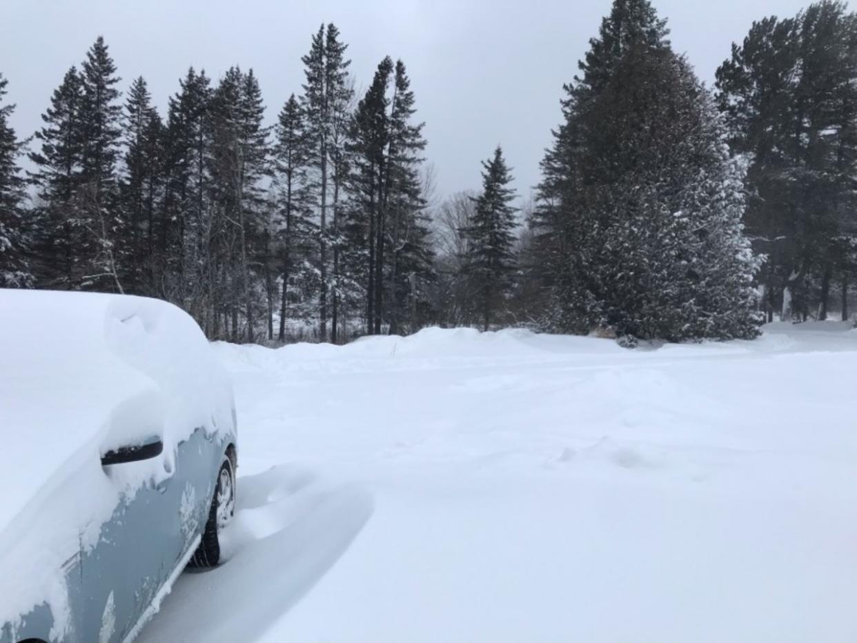
Ontario's quiet winter thus far is no more, thanks to a disruptive, expansive Texas low that will bring a bevy of precipitation types Tuesday and Wednesday.
Numerous winter storm warnings and special weather statements are in place across Ontario on Tuesday morning.
Going somewhere? Check out the current highway conditions before heading out!
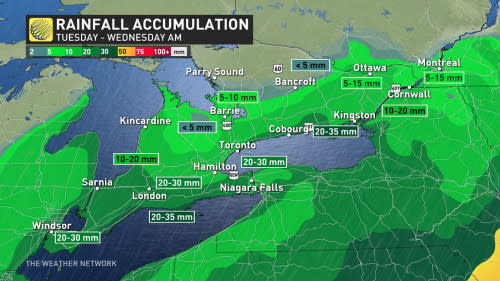
Some areas across Ontario are in line to see up to 25 cm of snow and 50-70 km/h wind gusts, in addition to heavy rain. As well, there is also the potential for freezing rain in some locales, so drivers will need to brace for dicey conditions.
As a result, widespread travel disruptions are likely as the storm pushes across the province. Snowfall amounts and the threat for icy conditions may catch some drivers off guard.
School busses are being cancelled for several school districts, including Halton Zone 3, Peel Zone 3, Guelph and Welling County, Huron-Perth, Nipissing-Parry Sound, as well as busses across Manitoulin Island.
Classic winter storm setup
It’s a classic winter storm that’s carving an unusual track. The sprawling low-pressure system will draw on cold air from Canada, warm and humid air from the Gulf of Mexico, and a tremendous amount of energy swinging over the Rockies to produce an array of hazardous weather across the continent.
Disruptive storms in the middle of January tend to track farther east than our current storm will. This system will move from Texas straight into the Great Lakes—a path more common of an early spring storm than a mid-winter soaker.
WATCH: Everything you need to know about messy Ontario storm
Precipitation starts as snow before switching to rain
Snow, rain and winds will comprise the first major system of 2024 for Ontario. Confidence is steadily increasing in the impacts.
The highest uncertainty will be snowfall totals along the Golden Horseshoe as the heavy snow versus rain line will be razor thin.
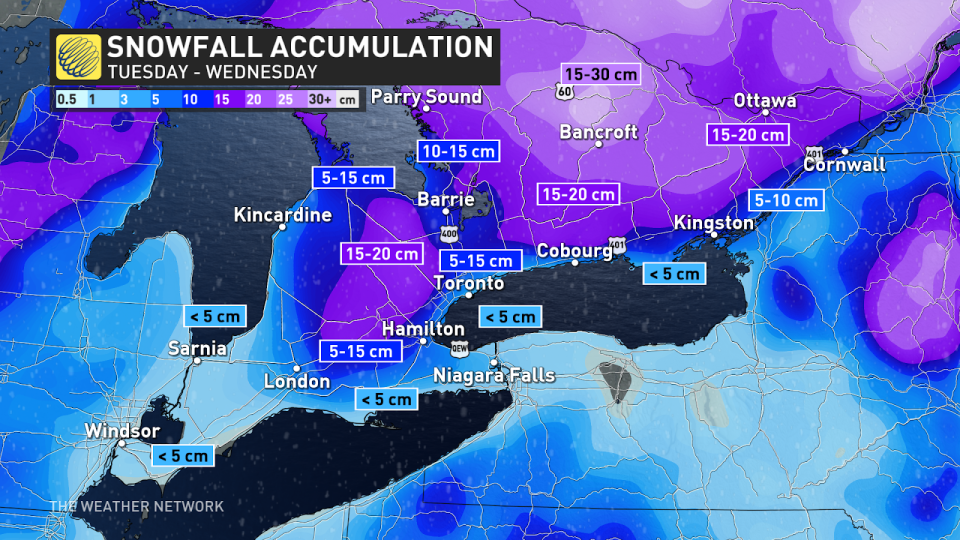
Expect a swath of heavy wet snowfall to develop on Tuesday morning across the southwest, moving into the Greater Toronto Area (GTA) late morning and eventually extending towards Ottawa Valley and northeastern sections by the afternoon.
Here’s where the forecast gets complicated: A transition to heavy rainfall is expected in southern Ontario as we head through Tuesday.
MUST SEE: Record-breaking: El Niño stole winter from Ontario in December
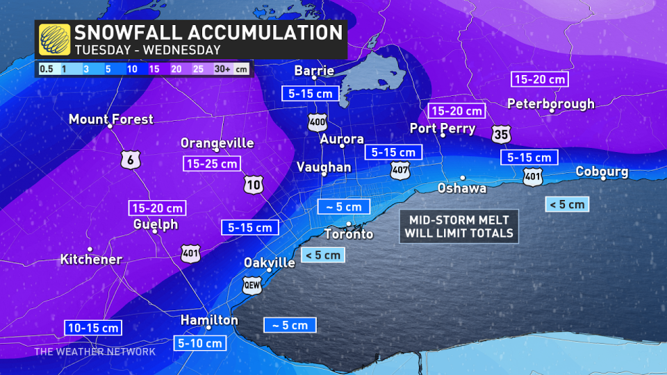
Areas that quickly change over include the Niagara Peninsula, and shorelines of Lakes Erie and Huron where snowfall amounts will be much lower. But, where the snow holds on will create difficult winter travel, and that includes several frequented highways north of Toronto.
The GTA cities closest to the lake shores may transition to rainfall first by late Tuesday afternoon. But, the 400-series highways (401, 407, 400) and higher elevations may hold onto heavy snow that may pile up to 10-20 cm.
Tuesday evening's commute will be severely impacted with blowing snow, as winds ramp up, as well. It's advised to avoid travel if possible, but, if not, make sure you leave extra time to get home.
Orangeville and Shelburne will transition through the evening after receiving 15-20 cm of snow, similar to Ottawa and northern parts of eastern Ontario. The transition begins Tuesday overnight, with a brief period of rain ending Wednesday morning.
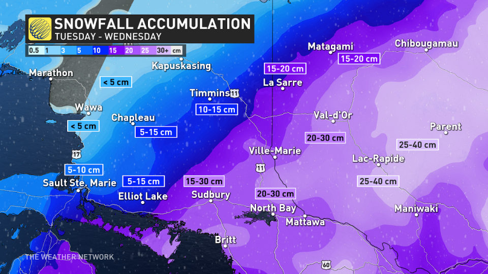
In Ottawa and parts of eastern Ontario, there is the chance for a period of ice pellets, and even freezing rain before a rainfall moves in. The heaviest snow will be in central and northeastern Ontario, where upwards of 30 cm of snow is possible. Places like Huntsville and North Bay will see some of the highest accumulations where it will remain snow for the entire system. Sault Ste Marie and Timmins will be on the northern edge of this system, where 5-15 cm of snow is possible.
Gusty winds likely through Wednesday
Strong winds will develop Tuesday morning, first out of the southeast, which will help to continue the snow, so the milder temperatures will remain south. Tuesday overnight into Wednesday, however, winds shift to the southwest, and eventually west, bringing in milder temperatures.
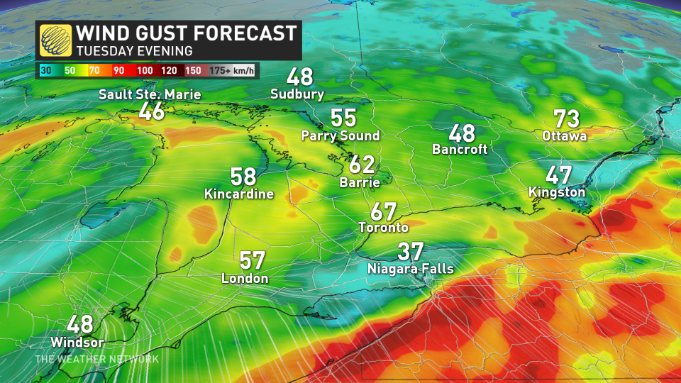
Wind gusts are expected to reach a widespread 50-60 km/h throughout Ontario, with some areas along the Lake Huron shorelines seeing upwards to 70 km/h.
Looking ahead
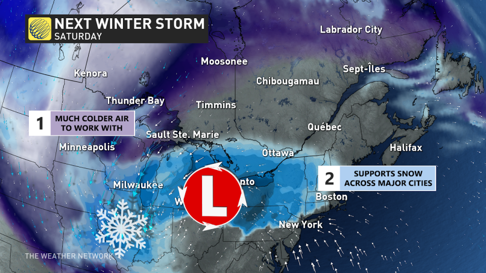
This period of active winter weather will continue for Ontario as a weak clipper system moves in on Thursday -- but the next system beyond that is the one to watch.
Late Friday and into Saturday, another strong, colder system is forecast to bring widespread heavy snow to the province. On top of that, it will bring in some of the coldest air of the season and set up some lake-effect snow for a couple of days.
Stay with The Weather Network for the latest on this major storm in Ontario
Thumbnail credit: Getty images/stock photo

