
First week of April to bring wintry storms to southern, eastern Canada

April showers bring May flowers, as the saying goes, but April snow storms?
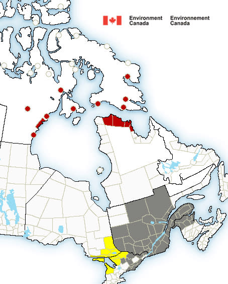
Environment Canada has issued weather alerts to New Brunswick, Nunavut, Ontario and Quebec, with a massive storm expected to arrive on Tuesday.
“The Colorado low is a major storm,” said Brett Anderson, a senior meteorologist at AccuWeather. “And it’s going to have all sorts of weather with it.”
Snowfall will begin Tuesday afternoon, with Quebec City and Sudbury receiving as much as 20 and 30 centimeters of snow respectively. Those cities, along with Georgian Bay and North Bay, will be among the hardest hit.
“Travel in those areas is going to be very treacherous, I suspect, even though it’s early April,” Anderson said.
Areas of southern Ontario and Quebec are more likely to receive rain — as much as 25 milimetres of it — or a mixture of rain and snow, while northwestern New Brunswick will receive snow, freezing rain and ice pellets.
Precipitation will continue into Wednesday, with the storm reaching peak intensity overnight. Strong wind and cold air on Wednesday will freeze rain and slush on the ground and make for icy driving conditions.
Anderson said people who can’t avoid travel on Tuesday and Wednesday should try to do so only during the day.
“If you have to go out and travel, try to do it during the daylight hours, when the sun is shining above the clouds,” Anderson said, warning that road conditions in a winter storm often deteriorate overnight.
“[The sun] still has an effect, so if you have to be out, try and do it in the middle of the day when the roads are in the best condition.”
This week’s stormy conditions are courtesy of a Colorado low, an extreme low-pressure system that begins in the central United States and sweeps north toward the Great Lakes.
It will bring the precipitation, while lingering Arctic air turns that precipitation to snow and freezing rain.
While such low-pressure systems are common this time of year, Anderson said temperatures low enough to turn a typical April storm into a blizzard are not.
“This weather pattern is more reminiscent of what we normally see in early, or mid-March.” he said. “It’s definitely lingering longer than it usually does.”
Anderson said another storm, courtesy of an Alberta clipper weather system, will bring snow, cold temperatures and strong winds. Another storm will hit central and southern Ontario and southern Quebec on Thursday.
“You’re going to have to wait until probably around April 9th or 10th for things to start looking up,” Anderson said. “And getting back to normal, I think, would be a good thing for a lot of us.”

