
Heavy snow, ice likely as Ontario braces for high-impact storm
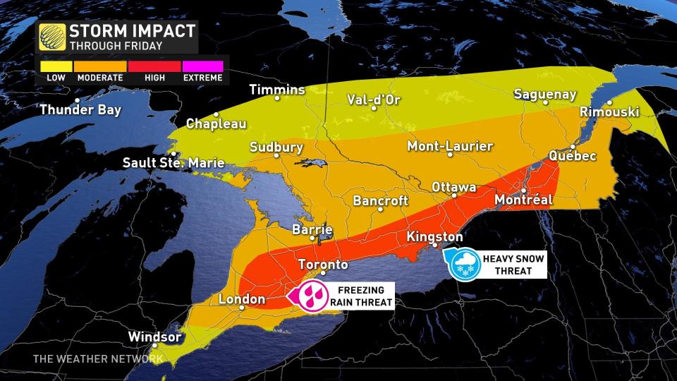
Widespread snowfall warnings and freezing rain warnings are in effect across southern Ontario ahead of a significant winter storm’s arrival on Thursday.
Dangerous travel is likely during and after the storm, and scattered power outages are possible across areas that see ice accretion on tree limbs and power lines.
DON'T MISS: Blizzard, twisters likely as 3,000 km-long storm eyes Canada, U.S.
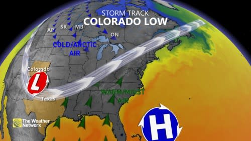
Southern Ontario’s impending bout of wintry weather is the result of the same Colorado low that’s brought blizzard conditions and deadly tornadoes to the U.S. this week.
However, this storm setup is quite complex due to the development of a second low late Thursday into Friday across the northeastern U.S.
The type of precipitation each community sees is also highly dependent on temperatures, with tiny changes in temperature determining whether it’s snow, freezing rain, ice pellets, or just a cold rain.
Whether it’s snow or ice, this will be a high-impact event and folks across the region should prepare for disruptions through Thursday and Friday.
WATCH: 3 things major storm will bring to S. Ontario this week
Freezing rain
The system will arrive in southwestern Ontario overnight Wednesday into Thursday morning, with precipitation starting out as rain before colder air at the surface allows freezing rain to develop.
By the pre-dawn hours, parts of the Greater Toronto Area (GTA), London and Grey-Bruce County will have a chance to see some freezing rain and ice pellets.
Widespread ice accretions of 2-5 mm are possible across southern Ontario from the shores of Lake Huron to the Hamilton area, reaching as far south as Highway 3 and as far north as Highway 10.

Forecasters expect the greatest icing to occur around the 401 between London, Kitchener, and Brantford, where 5-10 mm of ice accretion is possible.
Areas that experience icing will contend with slippery roads and sidewalks, along with the potential for isolated power outages and downed branches and limbs.
There will be the chance for some ice pellets as well, but this won't be a big risk.
Snow
Farther north and east, temperatures will remain cold enough that the predominant threat will be heavy snowfall.
Snow is expected to begin late Thursday morning and become heavy at times. Lower snowfall amounts are expected near Lake Ontario where snow may transition to rain.
Between 5-15 cm of snow is possible for the GTA lakeshores as well as the Niagara region. Away from the lakes across the GTA, as much as 10-25 cm may fall.
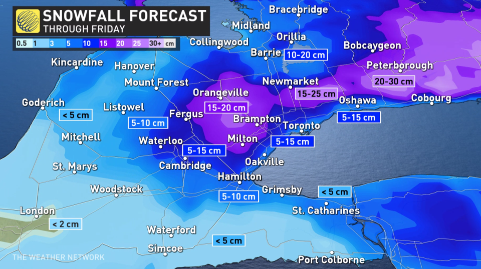
The heaviest accumulations are expected across eastern Ontario, where 20-30 cm of snow could pile up before the storm ends on Friday.
SEE ALSO: Your winter storm preparation checklist
Hazardous travel conditions expected due to heavy snow, including for the Thursday evening and Friday morning commutes. Consider postponing non-essential travel until conditions improve.
Winds
Winds will accompany the wintry precipitation and make matters worse. Southeasterly wind gusts up to 70 km/h are possible, particularly near Lake Ontario. Gusts between 60-80 km/h could also impact areas near and along Lake Huron and Georgian Bay.
Loose objects may be tossed by the wind and power outages may occur.
Wind gusts will pick up overnight Wednesday and peak during the day on Thursday.
WATCH: Heavy impacts to commute times through Thursday
Look ahead: Lake-effect snow develops, eyeing another potent storm next week
Bands of lake-effect snow are likely this weekend east of the Great Lakes.
Forecasters are also watching the potential for another significant storm mid-to- late next week. Frigid weather is expected for Christmas, Boxing Day and beyond -- for the final week of 2022.
Check back for the latest on the forecast across southern Ontario.

