Hurricane Harvey is the biggest flood threat of any U.S. storm in modern times

Hurricane Harvey is expected to hit the middle Texas coast late Friday night as the most intense such storm to strike the U.S. since Hurricane Wilma in 2005. But its winds, which will rank as at least a Category 3 storm on the Saffir Simpson Scale, are not the biggest threat Texans face.
Instead, this storm is going to destroy lives and property with water — both from storm surge flooding and staggering, record-shattering inland flooding.
SEE ALSO: Worst case scenario looms for Texas with Hurricane Harvey
The rainfall amounts currently forecast are almost too high to comprehend — upwards of 40 inches may fall from the Corpus Christi, Texas area northeastward to the Houston and Galveston region, and potentially extending into western Louisiana as well. Areas inland toward Austin and San Antonio may also be heavily impacted.

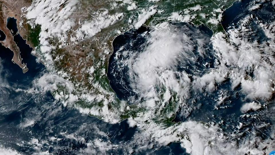
Image: rammb/cira/colorado state university
The National Weather Service is ratcheting up its language to make sure people understand that this storm is not a normal event. In fact, meteorologists are having difficulty recalling such a dire flood forecast associated with a landfalling hurricane.
Other recent storms have had strongly worded warnings and a high flood potential, including Hurricane Joaquin in South Carolina during the 2015 hurricane season. However, that storm never made landfall. Tropical Storm Allison in 2001 devastated the Houston area, but its rains were far less widespread than the forecast calls for with Harvey.
In other words, Hurricane Harvey may stand alone in the history books if the epic deluge comes to fruition.
Words such as "devastating," "life-threatening," "record-setting," catastrophic," and "uninhabitable" are being used to describe the storm's impacts, mainly due to a combination of storm surge flooding at the coast and inland flooding from heavy rainfall.
"These high rainfall amounts will likely produce devastating and life threatening flash flooding," said a local statement issued by the National Weather Service forecast office in Corpus Cristi.
Rick Knabb, the hurricane specialist for The Weather Channel and former director of the National Hurricane Center, released a video on Youtube on Thursday expressing his extreme concern about this slow-moving storm.
The forecast calls for Hurricane Harvey to make landfall on Friday night or early Saturday morning, only to pinwheel along the Texas coast for days, potentially keeping the rain falling straight through Thursday of next week. If this happens, it would result in catastrophic flooding in regions already prone to this hazard.
The center of Harvey is moving over Gulf waters that are 1 to 2 degrees Celsius, or 1.8 to 3.6 degrees Fahrenheit, above average for this time of year, adding more fuel to power the hurricane.
In the Corpus Christi area, the peak storm surge is expected to be 6 to 12 feet above ground level from Mustang Island to Port O'Connor. Some other areas are expecting between 8 inches and a foot of storm surge, with flooding continuing for days.
What does the @NWS forecast of 6-12 ft of storm surge flooding from #Harvey mean? For reference, the ceiling at our office is 11 ft. @NOAA pic.twitter.com/A47IrOWYsu
— NHC_Surge (@NHC_Surge) August 25, 2017
A storm surge of 8 to 12 feet above ground level is expected in some areas, and the storm's slow movement means that flooding could occur from multiple high tides.
Storm surge flooding occurs when a storm piles water toward the coast, from a combination of strong onshore winds and low atmospheric pressure. Sea level rise from human-caused global warming as well as gradual sinking of some coastal land areas can exacerbate storm surge flooding.
The storm surge threat extends up the coast, to the low-lying Houston-Galveston area. This scenario is particularly dire since days of onshore winds and storm surge could hinder inland floodwaters from draining into the sea.
Hal Needham, a storm surge expert, wrote on his blog on Friday that the storm surge will be so prolonged that it will act to worsen inland flooding with a combo of freshwater and saltwater flooding.
The flood threat for Houston and Galveston may be greatest after Monday, as the storm meanders along or just offshore, piling water toward the coast and dumping heavy rain inland.
“The collision of these ingredients looks like a train and car headed for an intersection on the tracks,” he wrote.
“If Galveston Bay is raised by several feet for many days, and a wide area of Texas real estate receives 15-20 or more inches of rain, where is that rain going to go? Runoff into Galveston Bay and Galveston Harbor will be severely impeded and this will create a catastrophic compound flood event.”
NEW: NOAA's #GOES16 shows a "sandwich loop" — a combination of visible and infrared imagery — of #HurricaneHarvey today, August 25, 2017. pic.twitter.com/o4EBfF69xZ
— NOAA Satellites PA (@NOAASatellitePA) August 25, 2017
Meteorologists Jeff Masters and Bob Henson of Weather Underground wrote on Friday that this storm has few, if any, precedent in hurricane history.
“The historical record of U.S. hurricanes gives us few, if any, analogs for a major hurricane landfall that transitions into a multi-day rainfall event as prolonged, extensive, and intense as the scenario painted by multiple forecast models for Harvey.”
According to the NWS office in Houston, "the primary emphasis and greatest threat to life and property will be the extreme rainfall amounts that
will likely lead to a potentially catastrophic and prolonged flash flooding event."
Storm's slow movement is main concern
How much rain a hurricane produces is largely a function of its forward speed. With Hurricane Harvey, the forward motion once its center crosses the Texas coast between Corpus Christi and Houston may be essentially nil. This could lead to phenomenal rainfall totals.

Image: noaa/nhc.
Because the storm is likely to get trapped over South Texas for days, caught between two high pressure systems — one to the east, and the other to the west — it's also likely that inland flooding will be compounded by the strong onshore winds, which will discourage the floodwaters from draining into the sea.
Some computer models even loop the storm back out over the Gulf of Mexico, only to make a second landfall in northeastern Texas or western Louisiana early next week. Even the most sober-minded meteorologists have been reaching for superlatives on Thursday and Friday to try to warn Texans that what they are facing is no ordinary tropical weather system.
Such a scenario, with a water-laden hurricane making landfall and stalling out, is the stuff of nightmares for flood forecasters, since the number one killer from tropical cyclones is inland flooding. Though most people think of wind as a hurricane's greatest weapon, flooding kills nine out of 10 people who perish in such storms.

Image: noaa/wpc/weatherbell analytics
Parts of Louisiana are still recovering after record rains caused widespread damage in 2016, making this storm particularly unwelcome.
Texas has a history of major floods from slow-moving tropical storms or hurricanes. Tropical Storm Allison, which struck the Houston area in June of 2001, killed 41 people, and caused $9 billion in damage. Harris County alone had $5 billion in damage along with 22 deaths from that storm.
Since then, heavy rainstorms have continued to demonstrate Houston's vulnerability to heavy rains. A flood event in April 2016 virtually shut down the third largest city in the U.S. by flooding highways, parking lots, and overwhelming drainage systems.
Across much of the U.S. and around the world, extreme rainfall events are becoming more common as the world warms. In addition, scientists expect that as human-caused global warming continues and the atmosphere holds more moisture, tropical storms and hurricanes will produce heavier rains.
WATCH: Hurricane Harvey is intensifying in the Gulf of Mexico