
Major storm threatens Ontario with blizzard conditions, outage risk
Just as one storm system exits Ontario, the next is eagerly waiting in the wings -- with very little breathing room for clean-up in between recently.
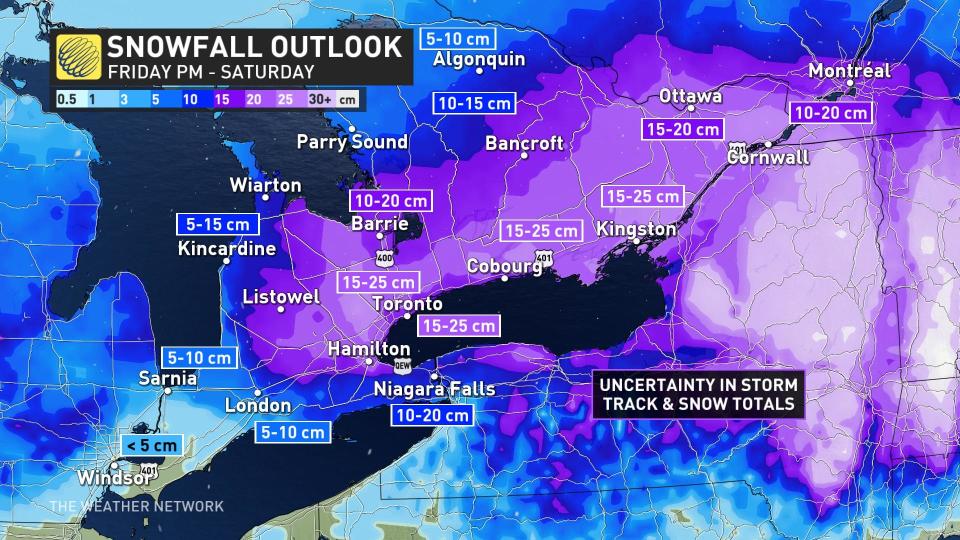
All eyes are now on the potent set-up for Friday, one that threatens a widespread swath of 15-30+ cm of snow through Saturday morning. Southern Ontarians should prepare now for significant impact and potential blizzard-like conditions.
Visit our Complete Guide to Spring 2023 for an in-depth look at the Spring Forecast, tips to plan for it and much more!
A Texas low will rapidly intensify as it tracks towards the Great Lakes, with ample moisture flowing in and heavy snow set to pick up through Friday evening. The storm will last into the first half of Saturday, possibly bringing the season’s heaviest snowfall totals to some parts of southern Ontario.
The intense dynamics and vast reserve of moisture will also spawn a dangerous severe thunderstorm outbreak across parts of the southern United States on Thursday and Friday.
The same energy feeding that rough weather south of the border will put southern Ontario squarely beneath a heavy band of snow that could drop 20-30 cm of snow. Couple that with strong winds and extensive blowing snow, and blizzard-like conditions are a major threat, especially near the west end of Lake Ontario.

TIMING: Conditions set to rapidly deteriorate Friday evening and overnight
Friday morning’s commute will likely unfold just fine. The latest model runs have trended the storm’s speed a bit slower, which could spare much of the Friday evening commute across the Greater Toronto Area (GTA).
MUST SEE: 'Common sense' driving tips to help steer through Canada's winter
We’ll see this low-pressure system advance toward the Great Lakes through Friday afternoon. Precipitation will begin pushing into southwestern Ontario by the late afternoon hours, steadily spreading toward the GTA for the evening and overnight.
The bulk of the precipitation we’ll see from this system will fall as snow—a change from the region’s recent systems—but warmer temperatures in the southwest will make this mostly a rain event there, and marginal temperatures could force some mixing around the Niagara Peninsula. Any northward nudge in the track of the low could nudge that mixing a little farther north.
MUST WATCH: Why Ontario should pay attention to this incoming storm
BRACE FOR: Dangerous blizzard conditions, potential power outages
Conditions will rapidly deteriorate as night settles in, with the heaviest snowfall and gustiest winds arriving through the overnight hours into early Saturday morning.
Winds could gust to 60-70+ km/h during the storm. Heavy snowfall combined with strong winds will lead to low visibility during the overnight hours, potentially rising to the level of blizzard conditions for a time. Travel will be difficult and dangerous at the height of the storm.

MUST SEE: Staying safe during a power outage
Temperatures hovering near the freezing mark will make this a heavy, wet snowfall. Gusty winds and the weight of this wet snow on trees and power lines will lead to an increased risk for power outages throughout the area. Remain mindful of trees and tree branches that could fall during the storm.
CLEAN UP: Snow lingers into Saturday for the post storm recovery
The centre of this impending storm will track south of southern Ontario, and its track will allow the band of heaviest snow to crawl along much of the most heavily populated corridor in the country.
We’ll see a hefty blanket of snow fall from the GTA into eastern Ontario. The heaviest accumulations will pile up where the heart of this band lingers the longest, while the potential for mixing could limit ultimate accumulations south of the GTA.
DON'T MISS: When should you take your winter tires off?
In all, we could see some areas hit 20-30 cm of snow across parts of southern Ontario by the time snowfall winds down on Saturday morning. The greatest uncertainty is how much of the region will see a changeover to ice and rain. The highest risk for a change over to a period of ice pellets and freezing rain will be for areas south and west of the GTA.
Light snow will linger throughout southern Ontario through the first half of Saturday as the system pushes east into New England.
Beyond this storm, temperatures will warm up a touch heading into the first weekend of March. Daytime highs approaching the mid-single digits will aid with cleanup efforts, though black ice will be a concern each night as lows drop below freezing.
WATCH: Do you know about the 4-4-4 rule regarding blizzards?
LOOK AHEAD: Great ski conditions likely for March Break
Colder than normal temperatures will return for the second half of next week and through the following week, which is March Break for most schools. At this point, we don't expect frigid weather, but not very spring-like either, with temperatures a few degrees colder than seasonal.
Southern Ontario ski areas should be in great shape for March Break.
Today may be the first day of #MeteorologicalSpring, but this year, astronomical spring begins on March 20. ☔❄️ Let's debate: Do you consider March to be a winter, or spring month? #TWNPoll #SpringForecast
Today may be the first day of The Weather Network on Twitter: "Today may be the first day of #MeteorologicalSpring, but this year, astronomical spring begins on March 20. ☔❄️ Let's debate: Do you consider March to be a winter, or spring month? #TWNPoll #SpringForecast / Twitter", but this year, astronomical spring begins on March 20. ☔❄️
Let's debate: Do you consider March to be a winter, or spring month? The Weather Network on Twitter: "Today may be the first day of #MeteorologicalSpring, but this year, astronomical spring begins on March 20. ☔❄️ Let's debate: Do you consider March to be a winter, or spring month? #TWNPoll #SpringForecast / Twitter" The Weather Network on Twitter: "Today may be the first day of #MeteorologicalSpring, but this year, astronomical spring begins on March 20. ☔❄️ Let's debate: Do you consider March to be a winter, or spring month? #TWNPoll #SpringForecast / Twitter"— The Weather Network (@weathernetwork) The Weather Network on Twitter: "Today may be the first day of #MeteorologicalSpring, but this year, astronomical spring begins on March 20. ☔❄️ Let's debate: Do you consider March to be a winter, or spring month? #TWNPoll #SpringForecast / Twitter"
Thumbnail image courtesy of Getty.
Stay tuned to The Weather Network for the latest on this major storm threatening southern Ontario.

