
Ontario: Periods of snow, ice make wintry weekend comeback
This week has certainly shown all the temperamental sides of spring across southern Ontario with bitter wind chills and below seasonal temperatures to start and then rain showers and double digit temperatures to end. Now, as we head into the weekend, and the last days of March, winter attempts its stubborn fight back with snow and ice threatening the forecast through Sunday. More on where this snow and freezing rain sets up, plus a more hopeful look into some pleasant April spring weather, below.
Spring is here! Check our UPDATED Spring Forecast to see what the season has ahead, plus get an EXCLUSIVE sneak peek at Summer 2019!
WEATHER HIGHLIGHTS
During the overnight hours on Friday and through Saturday morning, a rain/snow line sets up across southern Ontario
Accumulating snow likely for portions of cottage country and the higher elevations towards Grey Bruce
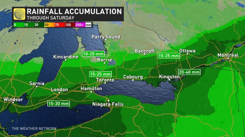
Heaviest amounts of rain focused across the southwest and northern shores of Lake Erie
Chillier temperatures through the weekend with brief risk of freezing rain for parts of eastern Ontario
Latest watches and warnings HERE
THIS WEEK DOESN'T END TOO BADLY
Although the first round of unsettled weather brought some scattered rain showers across southern Ontario through Thursday, the rising and milder temperatures didn't make things feel too badly by day's end. On Friday, the clouds will give way to more sunshine with temperatures hovering around the seasonal mark.
"Clouds will linger for much of the day towards Lake Erie and Niagara and the warmest weather will be to the north where we see the most sunshine," says Weather Network meteorologist Dr. Doug Gillham.
BURST OF WEEKEND SNOW, COOL AND BLUSTERY BY SUNDAY
While a major storm doesn't seem in the cards, March may be going out with at least a bit of a lion's roar for southern Ontario this weekend. A system tracking into the region through the overnight hours on Friday is set to bring rain, snow, and some blustery conditions.
"On Saturday, southern Ontario will be the dividing line between very warm weather to the south and colder weather just to our north. A soggy system will track along this boundary," says Gillham.
It's going to be a very fine line between rain and snow with this boundary, and where that line falls will mean the difference between some significant snowfall (at least, for late March), and a widespread soaking rain that develops later Friday night. The heaviest rain is focused around the southwest regions and along the northern shores of Lake Erie with between 20-30 mm expected. For much of the Greater Toronto Area, rain totals will amount to 10-20 mm.
That rain will change to freezing rain across parts of the northern Golden Horseshoe, well north of Highways 401/407 and above the escarpment.
"Across cottage country the rain will change to wet snow," Gillham says. "Periods of rain, with wet snow and ice to the north, will continue for most of the day on Saturday with a large range in temperatures from north to south across our region."
By Saturday night, the rain will change over to wet snow for much of southern Ontario before gradually ending through the overnight hours.
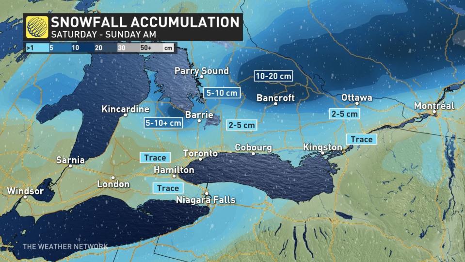
SNOWFALL TOTALS
For areas below the escarpment and near Lake Ontario, snow accumulations will be pretty minor with no major travel impact expected. It will be areas further north of the 401/407 and above the escarpment that will see the more significant accumulations through Sunday morning with 5-10+ cm possible in some spots.
Should the boundary dip further south however, particularly south of Lake Ontario, some slushy accumulations or periods of reduced visibility are likely to disrupt travel at times along the 401 corridor, for areas east of Toronto toward Kingston. The 407 east of Toronto and the 416 to Ottawa are also likely to see some slippery sections as the snow changes to freezing rain and persists for periods of the day on Saturday.
"Surfaces such as highways, roads and walkways may become icy and slippery as a result," warned Environment Canada in a special weather statement issued early Friday.
APRIL STILL TEMPERAMENTAL, BUT SHOWS SIGNS OF WARMING
Although the rain and wet snow will end by Saturday night, Sunday remains blustery and cool across much of the region. Colder than seasonal conditions are expected to persist into the start of April as well, although things look to take a turn for the warmer by the middle and end of next week.
"For the month of April as a whole we expect that temperatures will end up near seasonal - with slightly better odds that the final numbers will tip slightly to the warm side of normal," Gillham adds.
