
Brace for difficult travel in Ontario with two punch storm of ice and snow
A Colorado low is pushing a major winter storm into southern Ontario Wednesday through Thursday, bringing with it dangerous ice accumulation and snow that will heavily impact travel conditions and power lines. Expect multiple commute times to be affected.
"Its easterly track over the Great Lakes, coupled with Gulf moisture and a winter versus spring-like temperature battle, all offer conditions ripe for prolonged, icy precipitation," warns Rachel Modestino, a meteorologist at The Weather Network. "Some regions may be impacted for over 20 hours, with dangerous winter travel expected for the Wednesday evening, Thursday morning and even Thursday evening commutes."
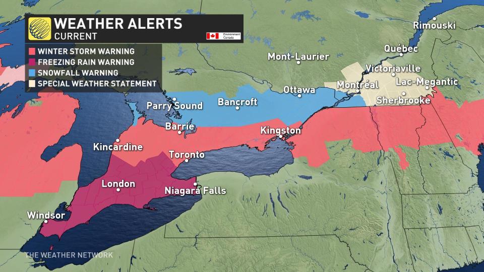
Prolonged freezing rain threat prompts widespread warnings
The bull's-eye for the most significant freezing rain will be in southwestern Ontario — from Windsor through London to the Niagara Peninsula. One of the most treacherous roadways will be Highway 3, north of Lake Erie and along parts of the 401.
Beginning Wednesday evening, precipitation rates are forecast to increase into the overnight hours, lasting well into Thursday morning.

Widespread freezing rain warnings are in effect for the region due to the prolonged nature of this event.
The amount of ice accretion will vary depending on surface temperature, wind speeds, and precipitation rates. It is important to keep in mind when viewing the ice forecast, that only approximately half the freezing rain that falls will accumulate on surfaces such as roads, tree branches and powerlines.
SEE ALSO: Here's how to stay safe during a winter power outage
With winds gusting over 60 km/h, tree and power line damage risks are widespread, with the threat for extended power outages through Thursday.

Threat for ice pellets and heavy snow
For the Greater Toronto Area (GTA), and regions to the north and east, there's more cold air funneling in from the north. This creates a much shallower melting layer, resulting in snow and ice pellet accumulations.
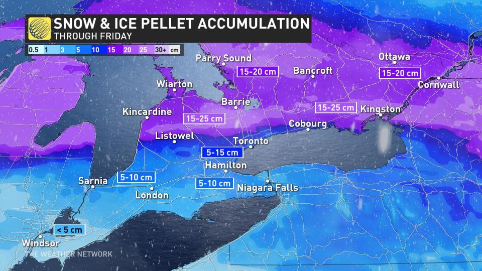
Between 5-15 cm of snow is expected to kick off the winter storm event through the Wednesday evening commute. Then, the snow will quickly transition to copious amounts of ice pellets, likely the most since April of 2018.
Ice pellets do not accumulate as readily as snowfall. They will still blow around and create slick surfaces, but the impacts are less than freezing rain. Don't be fooled, however, as ice pellets are very heavy, which makes them more difficult to shovel.
There'll be a substantial amount of ice pellets wedged between the snow and freezing rain. Some areas across the GTA might see upwards of 10 hours and 5-10 cm of ice pellet accumulation.
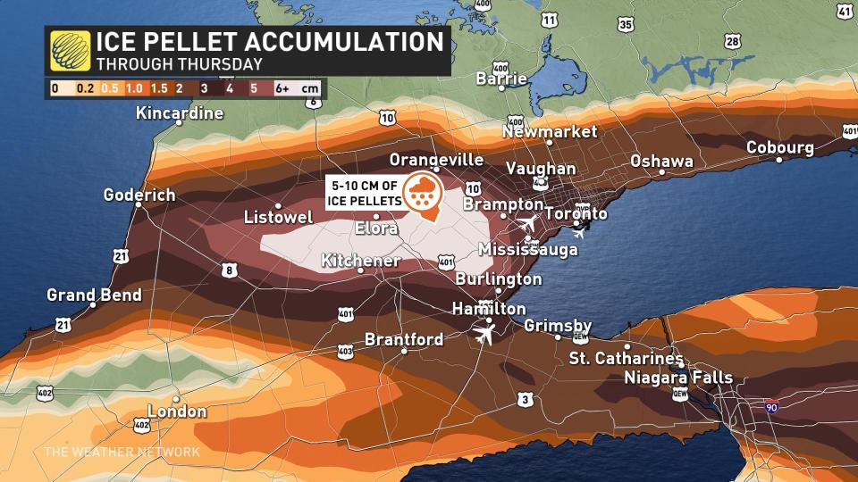
While ice accretion will be light, widespread winter storm warnings have been issued for the GTA and surrounding areas to the north due to the mixture of snow and ice.
There'll be some additional freezing rain on Thursday, adding more headaches for travelers and commuters.
WATCH: Anticipate travel delays as significant ice storm eyes southern Ontario
From the shores of Lake Huron to Kingston, and extending across eastern Ontario, there’s a higher probability to see over 20 cm of snowfall through Thursday.
Amounts start to fall off the further northeast you travel, but even the Ottawa region is looking at upwards of 20 cm of snowfall with this low, as the region stays on the cold side of this storm, prompting for snowfall warnings to be issued.
The system is forecast to depart Thursday night and exit the region on Friday.
Check back to The Weather Network for more updates and information on this winter storm in Ontario. For information on emergency plans and kits go to http://www.getprepared.gc.ca.

